

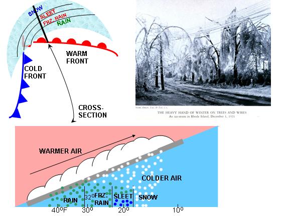
This weekends weather could be pretty wet. The latest GFS model run shows an area of low pressure developing over the TX/OK panhandles Saturday morning (map above left). In advance of the low, widespread light precipitation is expected to be falling from the Gulf of Mexico to Canada. In the morning on Saturday, the temperatures will have to be watched closely. If we are below freezing Friday night and the warm air moves in from the south it could ride up and over the cold air in place and produce some freezing rain on the onset of this storm until the temperatures in the lower part of the atmosphere begin to warm above freezing. During the day on Saturday (map above right) the low will move northeast and be located in eastern Kansas with a lot of moisture. There is some indication one inch of rain or more is possible. 
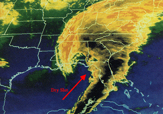
 The low will progress slowly to the east Saturday night and be located over northern Missouri (map above left) Sunday morning. Notice there is dry air (no green shading) from Texas into Arkansas northward into Missouri, this is called a dry slot. This dry slot my lighten up our precipitation on Saturday night/Sunday morning if located over Iowa. By Sunday evening (map above right) the low is located over northern Illinois and the moisture has wrapped around the low and the dry slot is no longer. As the low moves into this position the temperatures begin to fall. The blue lines are a general indication of temperatures cold enough for snow. Notice the colder air is now in eastern Iowa by Sunday evening. The possibility of rain changing to snow during the day on Sunday but the timing of the change over will be a big factor on if and how much snow might accumulate. There are still many factors that can change between now and than. For example if you look at the latest model run from GFS for Saturday evening...the position of the low is located in eastern Kansas. Yesterday's model run for the same time had the low in along the Missouri/Illinois state line. It appears it may be moving a little slower. Stay tuned to the latest forecast as the detail become more clear as the weekend gets closer.

 The low will progress slowly to the east Saturday night and be located over northern Missouri (map above left) Sunday morning. Notice there is dry air (no green shading) from Texas into Arkansas northward into Missouri, this is called a dry slot. This dry slot my lighten up our precipitation on Saturday night/Sunday morning if located over Iowa. By Sunday evening (map above right) the low is located over northern Illinois and the moisture has wrapped around the low and the dry slot is no longer. As the low moves into this position the temperatures begin to fall. The blue lines are a general indication of temperatures cold enough for snow. Notice the colder air is now in eastern Iowa by Sunday evening. The possibility of rain changing to snow during the day on Sunday but the timing of the change over will be a big factor on if and how much snow might accumulate. There are still many factors that can change between now and than. For example if you look at the latest model run from GFS for Saturday evening...the position of the low is located in eastern Kansas. Yesterday's model run for the same time had the low in along the Missouri/Illinois state line. It appears it may be moving a little slower. Stay tuned to the latest forecast as the detail become more clear as the weekend gets closer.



No comments:
Post a Comment